According to the National Hurricane Center ( in Miami, Florida, as of 5 00 PM ( on July 30 2020 the center of Tropical Storm Isaias was located near latitude 19 5 North, longitude 70 6 West Isaias is moving toward the northwest near 20 mph 31 km/h) and a northwestward motion with some decrease in forward speed is expected over the next couple of days.
According to the National Hurricane Center ( in Miami, Florida, as of 8 00 PM ( on July 29 2020 the disturbance was centered near latitude 16 0 North, longitude 66 3 West The system is moving toward the west northwest near 18 mph 30 km/h), and this general motion with a reduction in forward speed is expected over the next few days On the forecast track, the system will continue to pass south of Puerto Rico tonight, near or over Hispaniola on Thursday, near eastern Cuba and the southeastern Bahamas on Friday, and approach the northwestern Bahamas and southern Florida Friday night
Maximum sustained winds are near 45 mph 75 km/h) with higher gusts Some increase in strength is forecast through tonight, with weakening likely on Thursday due to land interaction Some restrengthening is possible by this weekend.
Environmental conditions are expected to be conducive for additional development, and a tropical storm is forecast to form tonight
According to the National Hurricane Center (NHC) in Miami, Florida, as of 5:00 PM (AST) on July 28, 2020, the disturbance was centered near latitude 14.4 North, longitude 55.9 West. The system is moving toward the west-northwest near 23 mph (37 km/h), and this general motion with some slight reduction in forward speed is expected over the next few days. On the forecast track, the system is expected to move through the Leeward Islands on Wednesday, near or over the Virgin Islands and Puerto Rico Wednesday night, and near or over Hispaniola on Thursday.
Maximum sustained winds are near 40 mph (65 km/h) with higher gusts. Some strengthening is expected during the next 48 hours, and the system is forecast to become a tropical storm tonight or Wednesday.
Environmental conditions are expected to be conducive for additional development and a tropical storm is forecast to form tonight or Wednesday.
Formation chance through 48 hours...high...90 percent
Formation chance through 5 days...high...90 percent
Tropical-storm-force winds extend outward up to 230 miles (370 km) primarily to the northeast of the center.
The estimated minimum central pressure is 1007 mb (29.74 inches).
According to the National Hurricane Center (NHC) in Miami, Florida, as of 11:00 AM (AST) on July 25, 2020, the center of Tropical Storm Gonzalo was located near latitude 10.5 degrees North, longitude 60.5 degrees West. Gonzalo is moving toward the west near 18 mph (30 km/h). A general westward to west-northwestward motion is expected today and tonight. On the forecast track, Gonzalo will move across the southern Windward Islands this afternoon or evening and over the southeastern Caribbean Sea on Sunday.
According to the National Hurricane Center (NHC) in Miami, Florida, as of 8:00 PM (AST) on July 24, 2020, the center of Tropical Storm Gonzalo was located near latitude 10 degrees North, longitude 56.3 degrees West. Gonzalo is moving toward the west near 18 mph (30 km/h). A general westward to west-northwestward motion is expected over the next two days. On the forecast track, Gonzalo will move across the southern Windward Islands Saturday afternoon or evening and over the eastern Caribbean Sea on Sunday.
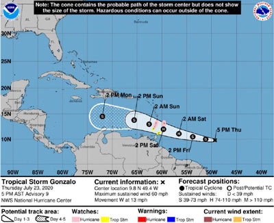
According to the National Hurricane Center (NHC) in Miami, Florida, as of 5:00 PM (AST) on July 23, 2020, the center of Tropical Storm Gonzalo was located near latitude 9.8 degrees North, longitude 49.4 degrees West. Gonzalo is moving toward the west near 13 mph (20 km/h). A westward to west-northwestward motion with an increase in forward speed is expected through the weekend. On the forecast track, the center of Gonzalo will approach the southern Windward Islands Friday night and move across the islands Saturday and Saturday evening. Maximum sustained winds are near 60 mph (95 km/h) with higher gusts. Some strengthening is forecast during the next day or two, and there is still a chance that Gonzalo could become a hurricane. Weakening is expected after Gonzalo moves into the Caribbean Sea.Gonzalo is a tiny tropical storm, and tropical-storm-force winds extend outward up to 25 miles (35 km) from the center.The estimated minimum central pressure is 1000 mb (29.53 inches).
According to the National Hurricane Center (NHC) in Miami, Florida, at 8:00 PM AST, the distinct eye of Hurricane Dorian was located near latitude 26.6 North, longitude 77.6 West. Dorian is moving toward the west near 5 mph (7 km/h). A slower westward to west-northwestward motion is forecast during the next day or two, followed by a gradual turn toward the northwest. On this track, the core of extremely dangerous Hurricane Dorian will continue to pound Great Abaco and Grand Bahama Islands tonight and Monday.
Maximum sustained winds remain near 185 mph (295 km/h) with higher gusts. Dorian is a category 5 hurricane on the Saffir-Simpson Hurricane Wind Scale. Some fluctuations in intensity are likely, and Dorian is expected to remain a catastrophic hurricane during the next few days.
According to the National Hurricane Center (NHC) in Miami, Florida, as of 5:00 PM (AST) on August 31, 2019, the eye of Hurricane Dorian was located near latitude 26.2 North, longitude 74.4 West. Dorian is moving toward the west near 8 mph (13 km/h) and a slower westward motion should continue over the next day or two followed by a gradual turn to the northwest. On this track, the core of Dorian should move near or over portions of the northwestern Bahamas on Sunday September 1, 2019.
Maximum sustained winds are near 150 mph (240 km/h) with higher gusts. Dorian is a category 4 hurricane on the Saffir-Simpson Hurricane Wind Scale. Hurricane-force winds extend outward up to 30 miles (45 km) from the centre. Tropical-storm-force winds extend outward up to 105 miles (165 km).
According to the National Hurricane Center (NHC) in Miami, Florida, as of 5:00 PM (AST) on August 28, 2019, the centre of Hurricane Dorian was located near latitude 18.8 North, longitude 65.5 West. Dorian is moving toward the northwest near 14 mph (22 km/h). On this track, Dorian should continue to move away from the British Virgin Islands during the next several hours and then move over the open Atlantic well east of the southeastern Bahamas on Thursday and Friday. The estimated minimum central pressure is 997 mb (29.44 inches).